Vietnam's Geography
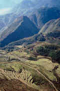
 There are four geographic sections in Vietnam, ranging from rugged mountains to marshy fertile flatlands. Vietnam's "S" shape takes it from China, in the north, the the Gulf of Thailand in the south. In the north, there are mountains that extend up to 3.143 m at Fan Si Pan, the highest point in Vietnam; the east and southeast consists of the Red River Delta, an alluvial plain; south of this Delta is the Truong Son (Annam Highlands) which is considered to be the backbone of Vietnam. A plateau (Central Highlands) also occupies this area and can be found between Cambodia and the South China sea. The Mekong Delta is located in the southernmost portion of Vietnam and makes up a fertile, marshy flatland that goes from the Central Highlands (north of it) south to the mangrove swamps on the Ca Mau peninsula.
The Red River and the Mekong River are navigable in their entirety and are considered to be the two major rivers in Vietnam. To help prevent flooding in their deltas, a system of dikes and canals has been erected. This has helped improve farming in the Mekong Delta due to salt water flooding from the South China Sea, especially during the long, wet monsoon season.
Vietnam's climate is amazingly varied, but this is due to the vast range of latitudes and altitudes in the country. The average temperature in the north is about 81 degrees F (27 degrees C) and in the south a nice 70 degrees F (21 degrees C) and is generally humid. Two monsoons control the weather, one is considered to be a dry monsoon which occurs mainly in the north from about October/November to March. The other brings wet, warm weather to the entire country, with the exception of the mountainous areas, from April/May to October. July and August are considered to be the hottest and most humid months.


No comments:
Post a Comment